The New Standard in Forest Intelligence.
Ilmarin’s AI-powered platform digitizes and analyzes forest data - giving owners, governments, investors, and consultants the clarity to act.
Traditional forest inventory is broken
Too slow — periodic ground surveys take months and are outdated before they are used
Too expensive — traditional cruising costs make frequent monitoring economically unviable
Too imprecise — sample-based methods miss what matters at the stand and tree level
Too slow — periodic ground surveys take months and are outdated before they are used
Too expensive — traditional cruising costs make frequent monitoring economically unviable
Too imprecise — sample-based methods miss what matters at the stand and tree level
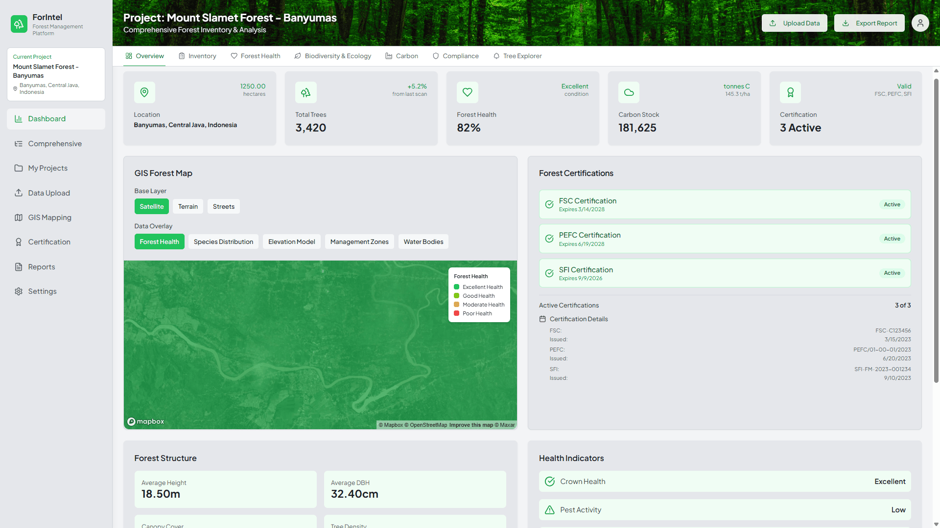
What Ilmarin Does
Ilmarin ingests data from various sources and turns it into a single, verified picture of your forest and every individual tree.
Collect and ingest data from a variety of sources, including drones, satellite, and mobile devices.
AI-driven analysis of the data that provides a wide range of metrics for a complete picture of the forest down to each individual tree.
The results of the analysis are presented on screen and in reports in way that is easy to understand and actionable.
How It Works

Step 1
Data Collection - Drone Flight
We deploy professional-grade drones equipped with RGB, LiDAR, and hyper/multispectral sensors across your forest area. A single flight mission covers large concessions efficiently, capturing the raw data that traditional ground crews cannot.
Step 2
Process
Our platform runs the collected data through purpose-built AI and machine learning models that identify, classify, and measure what matters. Processing that would take specialists weeks is completed automatically, with consistent accuracy across every run.
Step 3
Deliver Insights
Ilmarin delivers your results as structured, actionable data: forest health metrics, biodiversity indicators, and change detection outputs formatted for internal decision-making, regulatory reporting, or investor disclosure.
Precision at Scale
Who It's For
If accurate, timely forest data is critical to your operations, reporting, regulatory oversight, or policy decisions, we built this for you.
Forest concession holders and plantation managers
Sustainability and ESG reporting teams
Carbon project developers and verifiers
Conservation organizations and land trusts
Government forestry agencies and regulators
Certification bodies and auditors (e.g., FSC, RSPO, PEFC)
Financial institutions with forest-linked asset exposure
We Know Technology and Forests
Precision forest resource inventory and management require three things done well: drone-based data collection, AI and data analysis, and deep knowledge of Southeast Asia and its forests. Ilmarin was built by people who have spent careers mastering all three. Our team has developed AI-driven analytics grounded in peer-reviewed research, managed drone survey projects across Indonesia, and maintained active operations in the region for over 15 years. We didn't assemble these capabilities to enter the forest sector. Instead, we built Ilmarin because we were already here.
Precision forest resource inventory and management require three things done well: drone-based data collection, AI and data analysis, and deep knowledge of Southeast Asia and its forests. Ilmarin was built by people who have spent careers mastering all three. Our team has developed AI-driven analytics grounded in peer-reviewed research, managed drone survey projects across Indonesia, and maintained active operations in the region for over 15 years. We didn't assemble these capabilities to enter the forest sector. Instead, we built Ilmarin because we were already here.
Let's Start With Your Forest
One flight mission. Complete forest intelligence. Let's talk.